


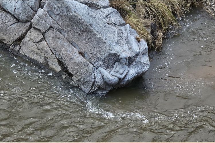
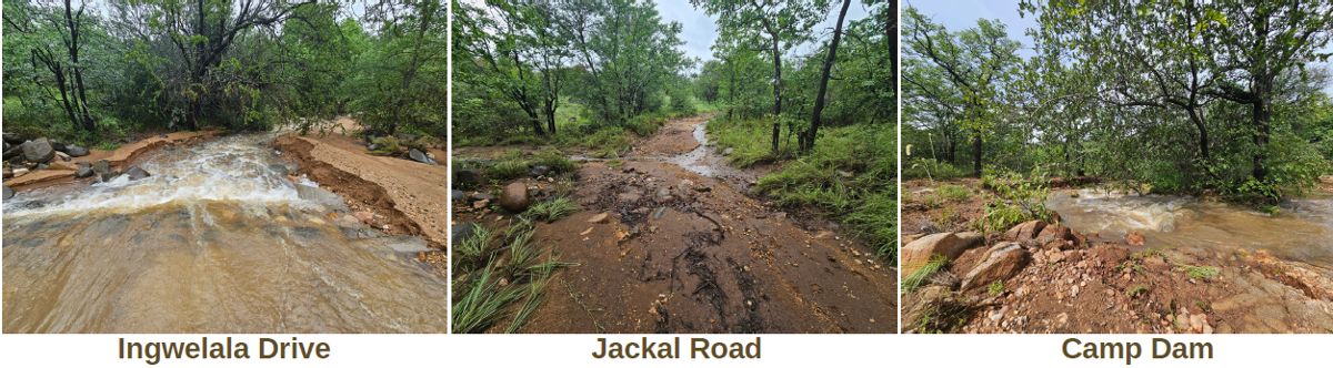
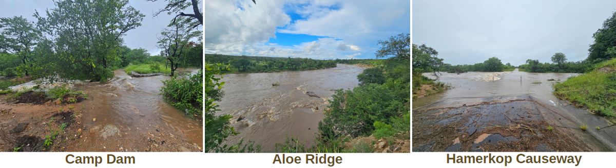
January brought some immense challenges for the year ahead, with unprecedented rainfall and a flood that lasted almost two weeks.
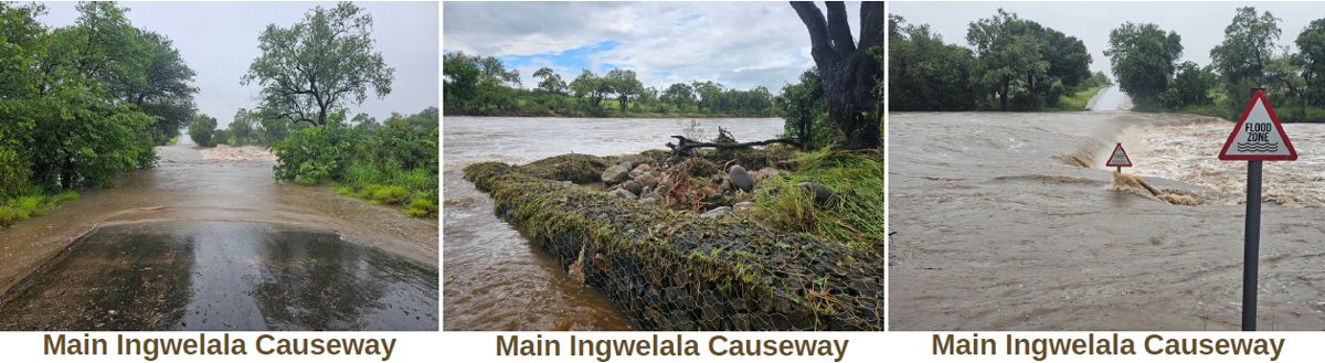
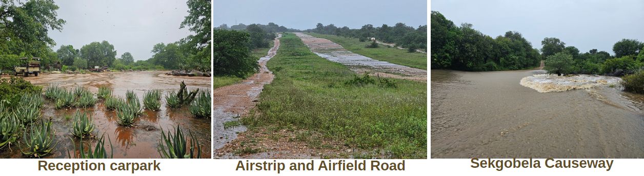
An enormous amount of erosion and damage was left in its wake. All roads and causeways were closed and completely waterlogged and, as a result, the camp was closed for most of the month.
Despite the challenging conditions, the team on the ground did their best to ensure that everyone was safe, that resources could be conserved and that the morale in camp remained high. Efforts throughout the month encompassed travel logistics management for those on the reserve at the time of flooding, varied and ongoing damage assessments, rehabilitation and repair-work, where possible and immediately necessary, and continual work on the main causeway on the Argyle Road to allow lighter vehicles to pass safely by the end of the month.
We would like to extend our heartfelt gratitude for your support, patience and understanding throughout this challenging period.
For your interest, a summary of our climactic figures from the month is below.
 Lowest Temp: 19.3°C (Avg: 21.6°C)
Highest Temp: 37.9°C (Avg: 29.4°C)
 Rainfall for the month: 733.5mm
(Avg: 105.3mm)
Year-to-date (July to June): 992.9mm

 Fire Danger Index: Dangerous


A look into the January floods and rainfall statistics
The flooding event experienced during the month sets a new record for Ingwelala, according to 43-year historical rainfall data for the reserve. Rainfall is manually measured every morning, at the same time, and compiled for each month and annual rainfall period. Out of interest, annual rainfall data is compiled from July to June, beginning in one calendar year and ending in the next. As such, we are currently just beyond mid-way in the current rainfall year.
Please see the below breakdown of the rainfall measured during the month, and a comparison with the 43-year historical rainfall data for Ingwelala:
- Total rainfall for the month: 733.5mm
- Rainfall over the 10-day period of flooding (9-18 January): 685.5mm
- Total annual rainfall thus far (July 2025 to date): 992.9mm
- Average rainfall for January: 90.4mm
- Average annual rainfall for Ingwelala: 447.8mm
- Monthly rainfall during Cyclone Dando event (January 2012): 341mm
According to Ingwelala’s historical rainfall data over the past 43 years, there have only been two occurrences where more rainfall was recorded over the annual period, from July to June, than what we measured over the 10 days of flooding in January 2026. Those were the 1984/1985 period (913.1mm) and the 1999/2000 period (923mm). Further, the total rainfall recorded in the current rainfall year exceeds any total annual rainfall in the historical data!
Please see the graph below, comparing monthly and annual rainfall (mm) measured in the current rainfall period (2025/2026) with the 43-year historical average, and the above-mentioned rainfall periods with higher annual rainfall than during the 10-day flooding period.
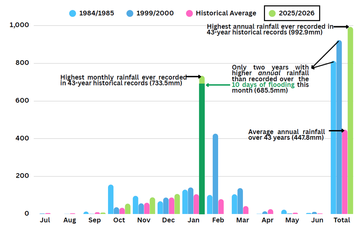
In summary, we measured more rainfall during the current rainfall year than any previous year in our historical data, and substantially more rainfall was measured over ten days than we would normally get in an average year.
Not only was there substantially more rainfall this month than any other period in Ingwelala’s recorded history, the extended period of active and heavy rainfall, spanning ten days of continual rain, is highly unusual (see graph below, highlighted in green). These combined factors directly resulted in complete saturation, extensive erosion, high levels of water run-off and a continual flow of all rivers regionally - all of which are still in flow at this time.
Please see the below graph showing the daily rainfall (mm) measured this month.

The reserve had to be temporarily closed because of the extensive rainfall and subsequent damage, much of which is still not traversable due to the high saturation level. Some of the damage included:
- A sinkhole on Ingwelala Drive, near the gate, that swallowed half of the driveable roadway.
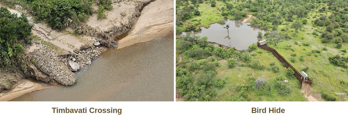
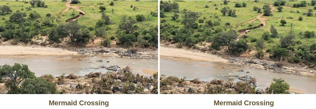
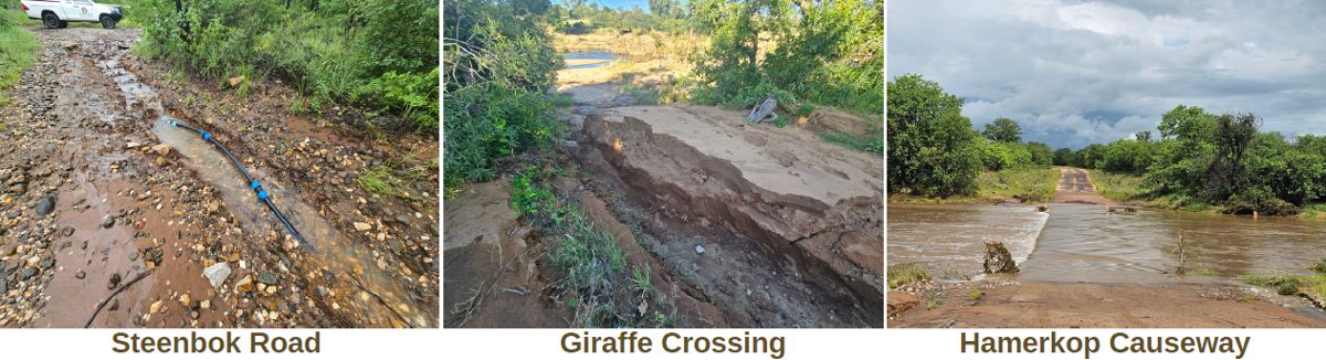
- Extensive erosion to the western bank of Mermaid Crossing, and the southern bank of Giraffe crossing, both roughly two metres deep and spanning long distances up the banks.
- Substantial erosion to the drainage lines on Ingwelala Drive, near #136, and Olifant Road, at Camp Dam, exposing bare rocks and requiring skilful 4x4 use for accessibility.
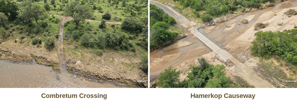
- Catastrophic damage to the western side of the Ingwelala causeway on the Argyle Road, rendering it impassable without significant interventions, both presently and in future.
- The main cemented causeway in camp over the Sekgobela River sustained catastrophic damage, rendering it impassable without significant ongoing and future interventions.
- Six of the seven main water supply lines to camp, Sibon Camp and Vuka Ingwe were fully compromised by the flooding rivers.
- All electric fencing at river crossings washed away completely.
- Complete waterlogging of almost all roads.
Other damage, not mentioned above, is extensive, and the scope and severity of the overall damage will undoubtedly increase as various areas of the reserve become accessible over time. As it stands, the reserve was officially re-opened on the 3rd of February 2026, with limited traverse on the reserve. Quick, temporary repairs were done to the roads in camp, making all of camp, and Sibon camp, accessible for Members as quickly as possible.
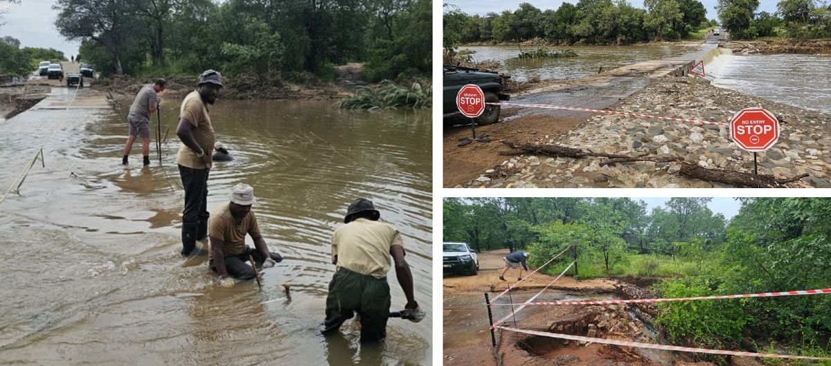
In the wake of the floods, the team worked hard to ensure basic assessments could be conducted in every department. From the aerial assessment and ground explorations, damage to causeways, the reserve, river crossings and roads is extensive. Both cemented causeways sustained severe structural and surface damage, the banks of the rivers and vegetation washed away, river crossings have experienced severe erosion - some of which has been catastrophic - roads became completely water-logged and fully saturated, and some dam walls have sustained localised damage. As a result of the high saturation level, portions of the reserve remain inaccessible, and will remain closed until such time that vehicular access can be safely restored to allow for further damage assessments and repairs.
Here is a small excerpt of what the team achieved, to repair damage and extend accessibility to various parts of the reserve, following this unprecedented event:
- All bungalows underwent preliminary damage assessments on foot
- Water supply from four of seven boreholes was successfully restored, largely on foot
- Part of the airstrip has been compacted and cleared, for emergency or limited use only*
- All roads in camp were graded and compacted for access to all bungalows
- All sinkholes and washaways in camp were repaired and compacted
- All causeways were cleared of immediate debris, and necessary sinkholes filled
- A temporary bypass for light vehicles was created at the main causeway on the tar road
- A temporary bypass was created at the Sekgobela causeway in camp
- Multiple roads on the reserve were repaired to allow traverse to various areas and sites, including various boundary roads and internal roads
- Power and water supply was restored to all parts of the reserve
Thank you to all for the hard work, dedication and effort put towards returning Ingwelala to its magical state, and a huge thank you to all who have supported the team during this time. A very special thank you is owed to the Warden and his wife for their continual logistical support throughout this event, and their daily regional communications, welfare checks and assistance.
*Please check with Reception before undertaking any flights to Ingwelala.
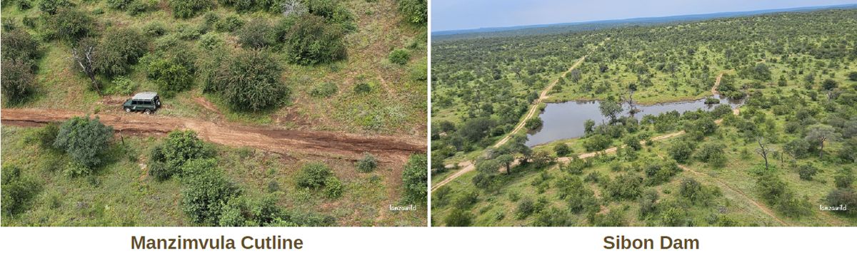
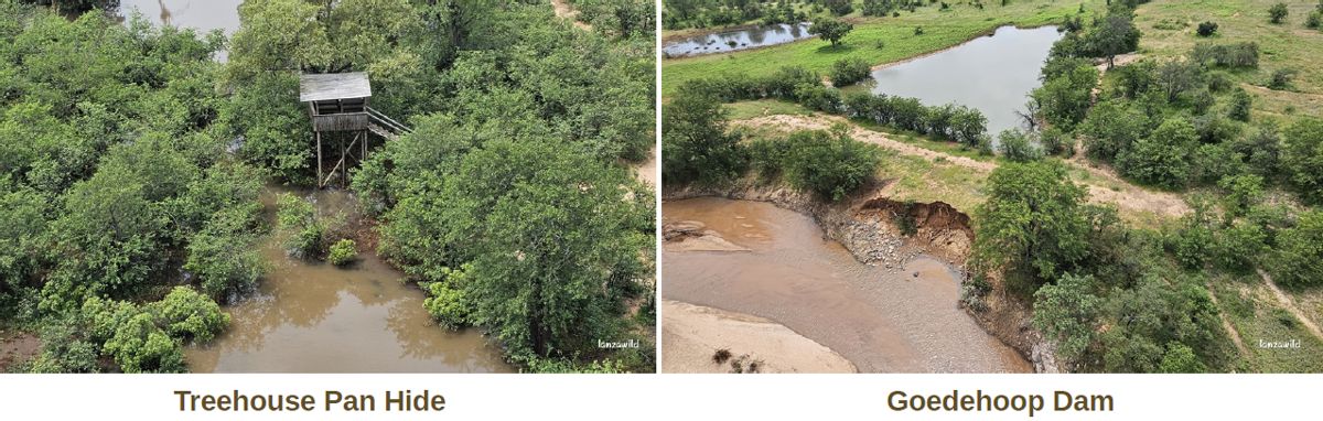
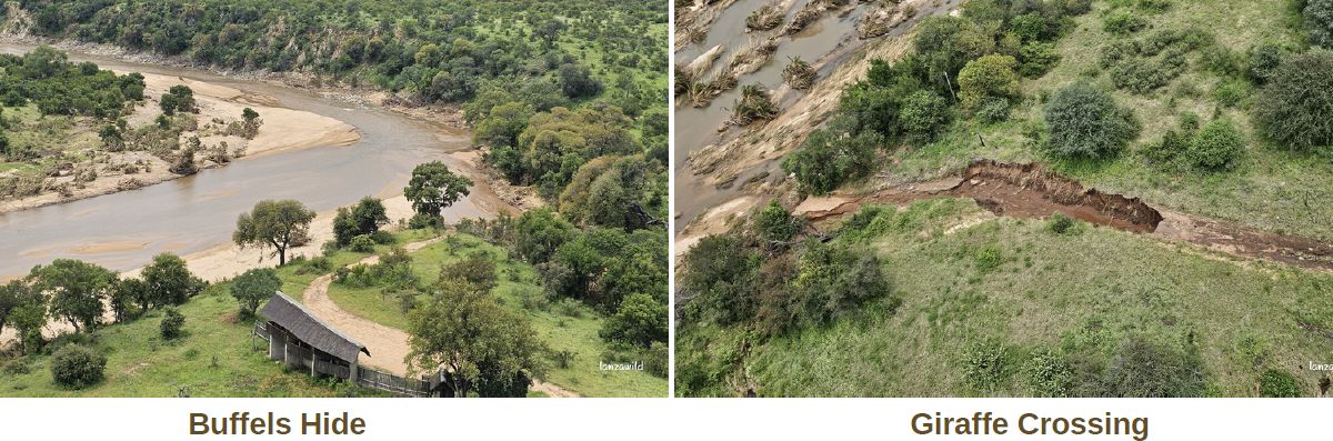
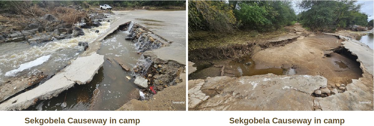
Approved traversing routes and interim road closures
In moving forward, we anticipate that many of the roads on the reserve will remain closed until such time that they can be accessed safely by the team for assessment and rehabilitation or repair. In the interim, set routes on the reserve that can be traversed, at your own risk, have been opened. Traversable routes are clearly demarcated on maps available at the entrance gate or at Reception.
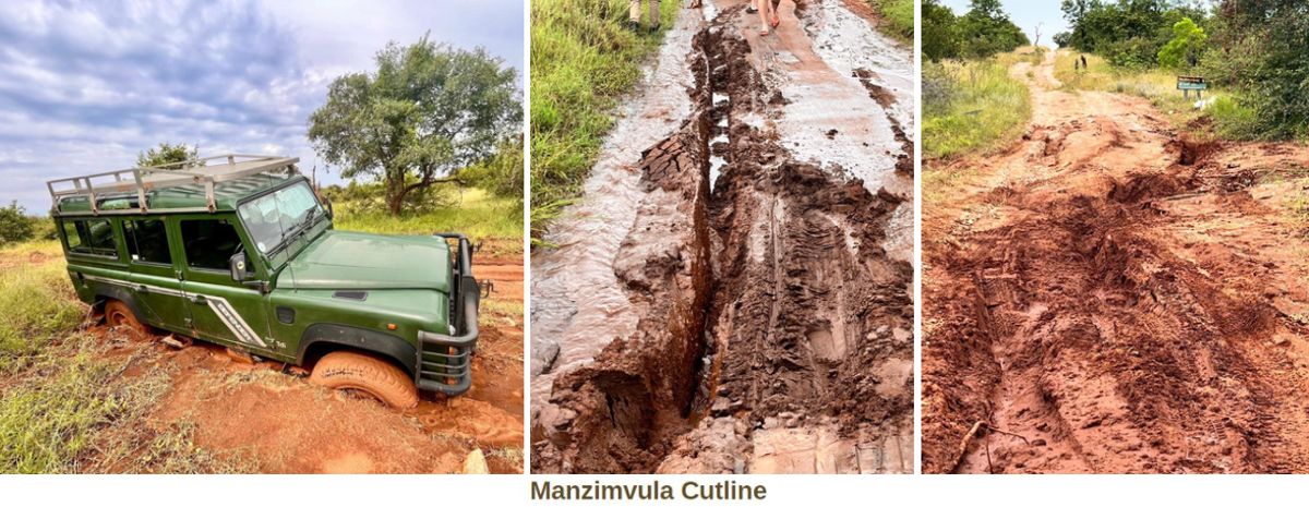
Please use 4x4 and extreme caution when traversing any of the open routes. Temporary repairs do not necessarily include the smoothing of road surfaces at this stage, and as such some road surfaces remain uneven. Caution is advised at any drainage line, or anywhere that rocks have been packed on roads to level the surface or fill sinkholes.
Please also note that all river crossings remain closed currently.
We wish to convey that these closures are out of absolute necessity. To conserve what is left of the roads, river crossings and resources available to us for both long-term rehabilitation and immediate attention to urgent or critical areas of concern, it is imperative that any further damage to roads and river crossings is avoided at all costs. By maintaining strategic road closures, we allow those roads sufficient time to dry out without further damage, allowing for more effective, sustainable and efficient repairs to be completed as soon as is possible and as soon as it is safe to do so.
It is also crucial that we prioritise safety for all, and that no unnecessary strain is placed on the limited human and mechanical resources currently, particularly with respect to callouts involving the recovery of vehicles. Not only does this remove focus from existing priorities, but it places immense strain on the mechanical equipment required to respond. Only the 4x4 tractor can be used to recover vehicles with the severity of the waterlogging, and we do not wish to put the tractor under any unnecessary strain as our most critical piece of mechanical equipment at this time.
We thank you for your patience, understanding and cooperation in this regard, as we move forward with the mammoth task of rehabilitation across the reserve, which will be undertaken on a priority basis moving forward. Should you wish to assist in some way, there are hand tools available at the entrance gate which can be signed out with the gate guard on duty. These can be used to trim vegetation away from the traversable roadsides. Please ensure that the tools are returned and signed back in on the same day. We thank you for your assistance!

Staff member of the month
Considering the events of this month, it is only fitting to thank all staff members who were on site during the flooding event, and in the wake of the floods for the remainder of the month. Every person has put an enormous amount of energy and dedication into assessing, repairing, rehabilitating, and so much more. Teamwork was essential at this time, and it was truly inspiring to see the team pull together in a spectacular fashion throughout. Without each person’s efforts, we would still not be able to access bungalows, traverse on the reserve, have drinking water or even flush toilets. Thank you for the truly incredible resilience and effort during the past month.
A special mention must go to John Llewellyn and the Board for their unwavering support, continual communication, and incredible efforts throughout a truly challenging time. We are immensely grateful for the enormous show of support and positivity throughout.
Lastly, we would like to thank all Members who contributed towards the ongoing efforts, offered support or logistical assistance, and exercised positivity and patience during a truly trying period this month - whether from in camp or at home. Your assistance and support are greatly appreciated, and we thank you.

Building Projects
John Llewellyn, represents the Building Committee at reserve level regarding all building related issues to members bungalows. Members are welcome to call Reception ahead of their visits to enquire what building related disturbances may be encountered in the vicinity of their bungalows.
Current (major) building projects are listed below:
- Bungalow #124: Chameleon Builders; Internal renovations and re-thatch.
- Bungalow #197: Chameleon Builders; Thatch comb and patch.
- Bungalow #207: Chameleon Builders; Internal renovations. Re-thatch to folllow.
Notes from the conservation team
Considering the enormous amount of damage on the reserve following the record-setting rainfall this month, we would like to thank everyone for their patience, understanding and support as we move forward with priority-based repairs and rehabilitation in camp and on the reserve. This is particularly pertinent to the roads and traverse on the reserve currently - especially river crossings, which are currently unusable.
Undoubtedly, repairs will take time and will require our team’s undivided attention as much as possible. We would like to request that should there be any areas of concern, that you please contact us or leave a note at Reception - we will gladly assist you as soon as we can - and thank you in advance for your patience as we move forward.
Should there be any specific opportunities where special assistance may be required from Members, these will be communicated with everyone in camp via the morning radio announcements, and hand tools are available at the gate for verge trimming should you wish to assist in that way. Should you wish to assist further, please contact us or leave a message at Reception for us, and we will contact you.
In the interim, we thank you for your patience as we continue exploring, assessing, repairing and rehabilitating - one step at a time. We know it will be a long road ahead, and we are grateful for your support.
Words by Tess Woollgar, images as credited above.